Last updated on May 15th, 2026
Hiking Mount Hallasan, the tallest mountain in South Korea is a must-do for every Korean. See how we join the hike to the summit during my Jeju road trip.
Hike up to the top of Mount Hallasan, the tallest mountain in South Korea is a must-do for every Korean. During our road trip journey at Jeju, we took the opportunity to join the hike to the highest point of South Korea, the summit of Mount Hallasan.
Natural hikers don’t miss out on the opportunity!
Considering its popularity, limited information can be found about hiking Mount Hallasan. So hopefully my hiking experience to the summit of Hallasan Mountain can help to ease your coming hiking journey.
Overview: Mountain Hallasan
Standing proudly at the center of Jeju Island, Mt Hallasan is the most memorable landmark of Jeju Island with an altitude of 1950 meters above sea level. Listed as World Natural Heritage in 2007, Mount Hallasan is an active volcano but does not react for a very long time. The last volcanic eruption of Mount Hallasan was 1007 years.
Hiking at Mt Hallasan is only limited to day hikes as it is very dangerous at night due to the trail condition. Time control varies depending on the season and is strictly enforced to climb down before the sunset. Take note that hiking hours are subject to change according to season and park rangers’ discretion.
For more information on climbing Mt. Hallasan, check the visitJeju official website.
Mt Hallasan Hiking Trails Option
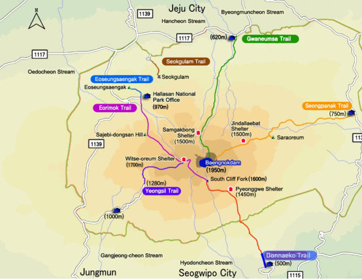
There are many hiking routes available. Seongpanak, Gwaneumsa, Yeongsil, Eorimok are the four common trails listed. However, not all of the trails can reach the summit. The Seongpanak and Gwaneumsa trails are the only two that allowed you to the top of Mount Hallasan.
- Seongpanak Trail: Most popular and convenient hike to the peak (4.5 hours for one way).
- Gwaneumsa Trail: Most beautiful hike but steepest among all the hikes to the peak (5 hours for one way).
- Yeongsil Trail: Popular during fall foliage. (2 hours for one way).
- Eorimok Trail: Most used by tourists (1-2 hours for one way).
Getting To Mt Hallasan Trails
Seongpanak Trail: The most popular trail among trails with public transport accessible and a large car park available. The easier route compared with Gwaneumsa which leads you to the peak.
- Length: 9.6 km / 4.5 hours for one way
- How To Get There: Public Transport: Jeju Intercity Bus Terminal – Seongpanak. Take Bus No. 781 or 781-1 (Jeju, Seongpanak, Seogui), and get off at Seongpanak Bus Stop. Travel time approx. 40 min.
- Korea GPS Tel No: 725-9950
Gwaneumsa Trail: Probably the most picturesque route according to the hiker but also the steepest among the hiking trails. It is steeper but slightly shorter compare with the Seongpanak trail.
- Length: 8.7 km / 5 hours for one way
- How To Get There: No public transport can directly to the trailhead but is easy to access by self-driving or taxi ride. A taxi from Jeju city is around or less than 15,000.
- Korea GPS Tel No: 756-9950
Yeongsil Trail is known as the best autumn foliage course in Hallasan with a gentle slope line.
- Length: 4.7 km / 2.5 hours for one way
- Korea GPS Tel No: 747-9950
Eorimok Trail is the most used by tourists on a tight schedule as it allows you to reach the midway point where you can enjoy a stunning view of the mountain but it won’t take you to the top.
- Length: 3.7 km / 2 hours for one way
- How To Get There: Jeju Intercity Bus Terminal – Eorimok. Take Bus No. 740 (Jeju, Yeongsil, Jungmun), and get off at Eorimok Trail Entrance Bus Stop. Travel time: approx. 45 min.
- Korea GPS Tel No: 713-9950~3
Preparation Before The Hike
Jeju City with almost 30-40 minutes of driving journey to the entrance of the Seongpanak trail. We bought some snacks, and energy drinks at the Emart nearby and have a good rest before the hike.
We were staying in Yedaoom Pension at Jeju City with almost 30-40 minutes of driving journey to the entrance of the Seongpanak trail. We bought some snacks, and energy drinks at the Emart nearby and have a good rest before the hike.
First of all, we choose to start our driving journey to the entrance of Seongpanak at 6.30 a.m to give more buffer time for our hike. The 30 minutes driving journey is very breath-taking during the early morning. We are soon arriving at the entrance of Seongpanak without noticing the time passing by. Ample car park is available at the Seongpanak entrance.
If you need help in choosing a reliable car rental company in Jeju, take a look at RentalCars from Booking.com. It has a high reputation among customers and easily navigates to compare various car rentals for the best price guarantee.
Useful Tips: Hiking Mount Hallasan
- Start Earlier: I seriously under-estimated how long it takes to climb Mt Hallasan – and to descend. Depending on which route you take, you might spend as many as 10 hours on the return journey. Start earlier in the morning to give more buffer time for your hiking journey.
- Energy bar and water: Be sure to drink enough water to keep you hydrated along the hiking journey. There is a store selling water and snack at the shelter but sometimes might not open. It’s still better to bring enough water and snack for the hike.
- Footwear: The rocky path can be uneven and hiking shoes or boots are a better option to protect your ankles especially during descending.
- Hiking Equipment: Not a necessity but it helps to relieve some of the burden on your knee with a handy hiking stick.
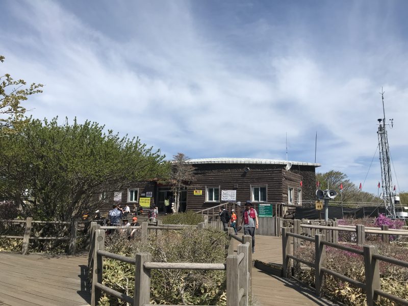
From Seongpanak Entrance To Sokbat Shelter
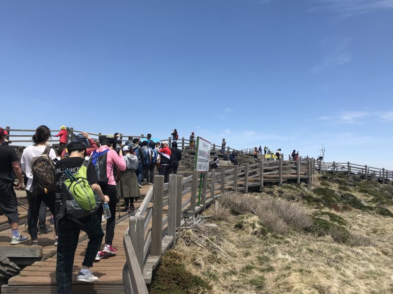
We start our Mt Hallasan itinerary after warm-up. At the entrance, a clear information on the time control to reach Jindallaebat Shelter before 13:00. You are prohibited to continue if you are unable to pass Jindallaebat Shelter before the controlled time. So make sure to start early and plan your hike accordingly based on your physical strength.
The Seongpanak trail takes about 9 hours with 19.8 kilometers for return.
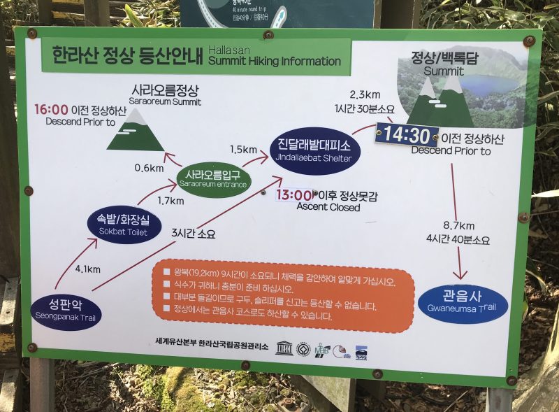
Starting from the entrance with an elevation of 750m, you will pass through three major resting points: Sokbat Shelter (4.1km), Saraoreum Entrance (1.7km), and Jindallaebat Shelter(1.5km) before reaching the summit, Baengnokdam (2.3km).
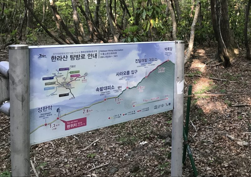
As shown above, different difficulty levels along the Seongpanak hike. Yellow/Easy from Seongpanak’s trailhead to Sokbat shelter, slowly getting harder to the Jindallaebat Shelter (Green/Normal) and the hardest part is the last 2.3km before reaching the summit, Baengnokdam (Red/Hard).
The hiking trail is well organized with informative signboards placed at each hiking point. Some trails are even covered with a twine woven blanket, which is super comfortable to walk. Be very careful on the rocky path with volcanic stone along the trail even at the starting point.
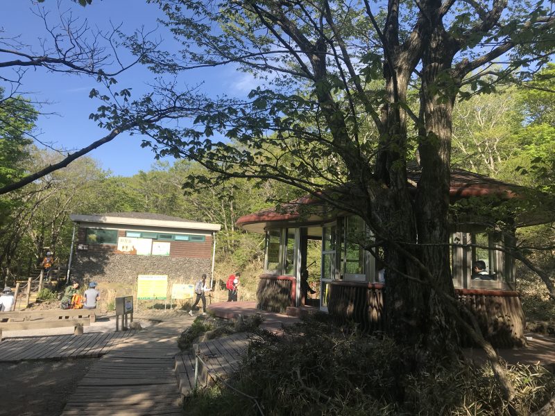
Arrived at Sokbat shelter at an altitude of 1070 meters. Restrooms and shelters are available here for resting but no water. We took a 10 minutes rest at Sokbat Shelter and went to the restroom. The condition of the restroom is very terrible, and we end up giving up.
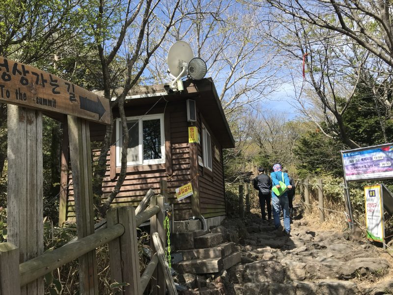
The Climb to Jindallaebat Shelter
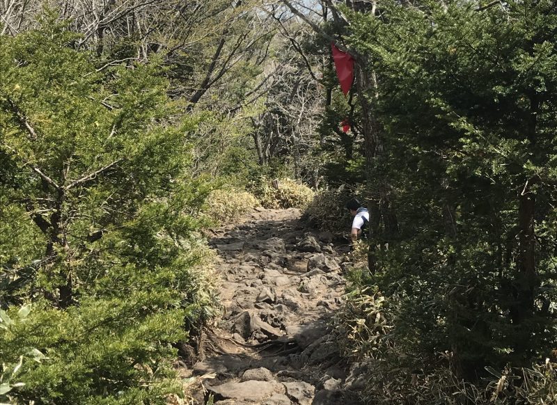
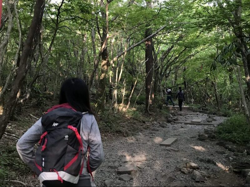
We continue pushed on our hiking journey from Sokbat shelter after the 10 minutes rest. The level of difficulty change from easy to normal. We started entering the nature reserve by passing through the wooden planks, and wooden bridge and continue to hike up. The rocky path starts to become steeper and rockier which makes your hike getting harder.
We didn’t rest when reaching Saraoreum Entrance and continued to push on to Jindallaebat Shelter. Again, the remainder is on the time control for the allowable ascent time.
The trail is in good condition with well wooden stairs and rope to hold to ease on climbing. But, what keeps on playing in my mind is “Stair, Stair, and more stair”.
After almost an hour of endless climb, we finally arrived at Jindallaebat Shelter, a perfect resting point after our 3 hours of hiking journey from the start point. I took this opportunity for a restroom break and relaxed for our weary legs. The condition of the restroom at Jindallaebat Shelter is much better than at the Sokbat shelter.
There is a store selling snacks at Jindallaebat Shelter, but unfortunately not open on that day. Luckily we have enough water to stay hydrated.
The view must be very breath-taking if we are coming during the purple azaleas blossom season.
Final Ascent To The Summit
The last ascending point to the summit is very challenging and harder. Compare with the easy-to-normal hike before reaching the Jindallaebat Shelter, it was another level of challenge for us.
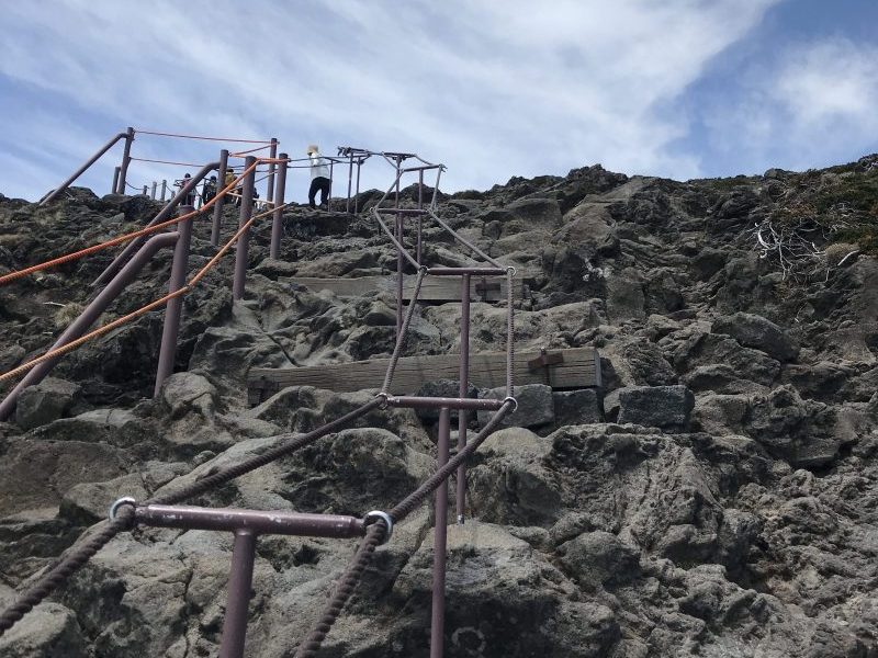
Some of the climbs are pretty sharp and steep as everything that can make for a soft landing is now gone. Be sure to be extra careful not failing down or hurt by the rocky stone along the pathway.
We took more rest when getting to a higher altitude.
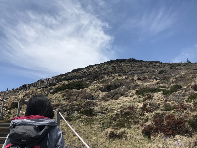
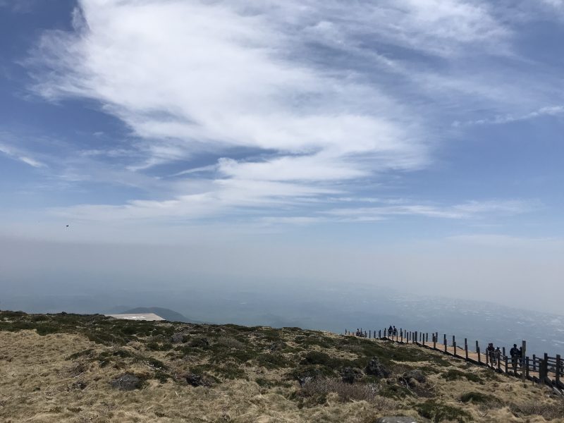
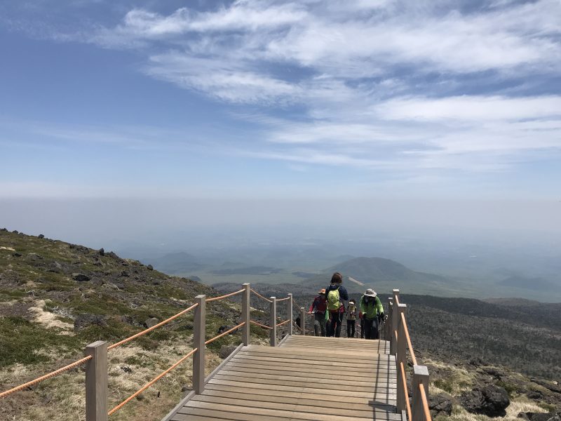
At some point, the forest starts to disappear and the trees are gradually replaced by clouds. See the wooden staircase in front, we are almost reaching the summit. Come on!
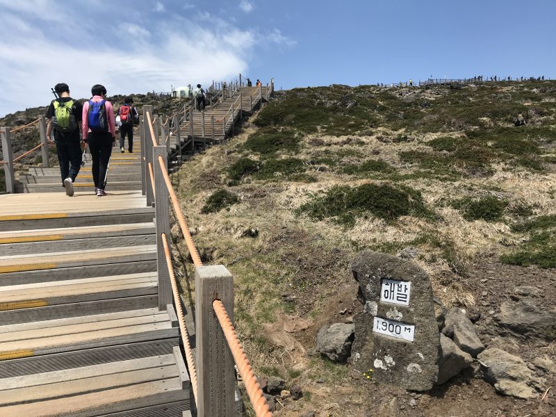
When you are at an altitude of 1900 meters, you will know that there is another 50 meters to the summit. The view behind was gorgeous with the entire forest underneath us. My legs are cramped and I need to rest for a few minutes for each move. Countless steps with endless points, but we know that we are slowly approaching the summit. The scenic route is the only motivation that makes us continue to move on.
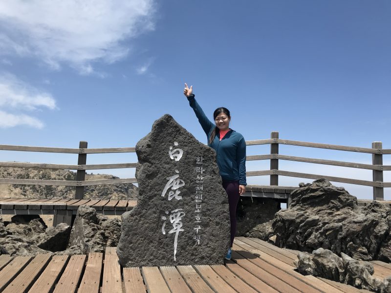
The Top Of South Korea – Mt Hallasan
We finally did it! The top of South Korea.
At the summit, there is a large open area for the hikers to take some rest. Hikers were busy taking photography at the obligatory summit stone and the crater lake.
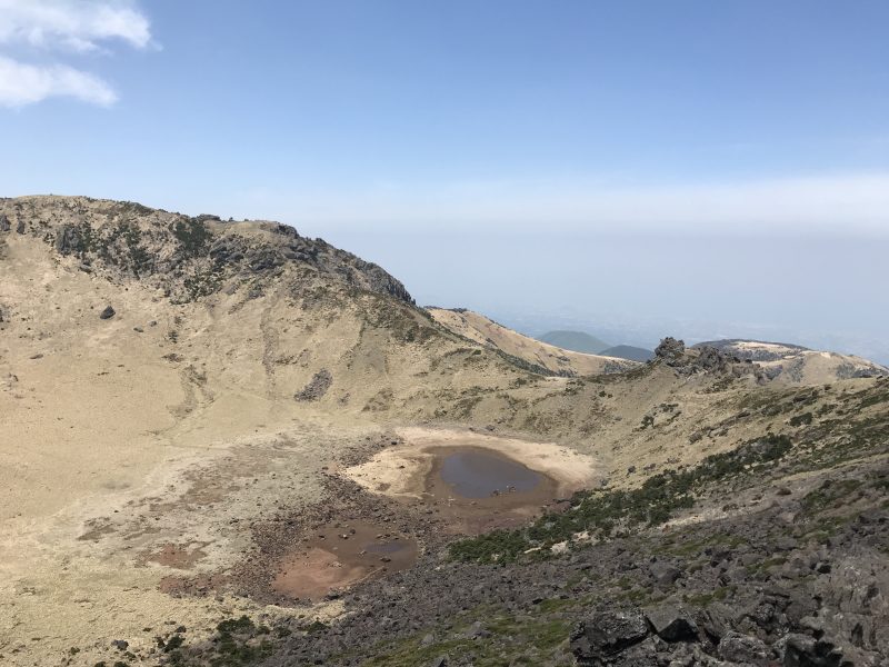
Baengnokdam, also meaning “white deer lake” is a volcanic lake at the summit of Mount Hallasan. Unfortunately, the water is almost dried out during our hike.
The hike-up journey took us almost 5 hours to reach the summit. We are resting for almost 30 minutes, eating our energy bar to restore some of the energy while enjoying the view at the top of South Korea.
Note: You need to carry your trash off the mountain. There are no bins at the shelter or anywhere along the trail.
The Descending Journey
We are descending to the ground by using the same route, the Seongpanak trail. The descending route is much more torture compared with the ascent. You are required to find a good balance and landing point between the uneven rocky path.
Our sincere advice, try to keep your step smaller and descent using the sideways to protect your knee. Our knees and ankles are so painful during the descending journey. More rest is required to relieve the pain to continue our journey.
We use a long time with approximately 5 hours to reach the ground from the summit. The tourist center information office is closed sharp at 5 p.m. and we failed to get the certificate for the climb. It doesn’t matter as the hiking experience is more memorable compared with the tiny piece of paper.
This Mt Hallasan travel blog recorded my hiking journey from the bottom to the summit. Hiking Mount Hallasan was so tired but satisfied. It had been a long but great hike.
Hiking Mount Hallasan: My Thoughts About The Journey
In short, I do not regret spending my day hiking Mount Hallasan itinerary during my Jeju road trip. I am so glad we didn’t give up and continued to climb to the summit. Reaching the summit of Mount Hallasan is the most memorable journey of my Jeju road trip.
So, my friends, don’t wait and you are ready to conquer the tallest mountain in South Korea!
Jeju Travel Tips And Foodie Guide
Check out our 6 days 5 nights Jeju itinerary and look for some inspiration to plan on your wonderful Jeju road trip.
- Jeju City Exploration – Yongduam Rock | Dongmun Market | Black Pork Street
- West Coastline – O’sulloc Tea Museum | Innisfree Jeju House | Yongmeori coast
- South Coastline – Daepo Jusangjeolli Cliff | Jeongbang Waterfall | Seogwipo Maeil Olle Market
- East Coastline – Sunrise Peak Seongsan Ilchulbong | Udo Island
- Hiking Mount Hallasan – Highest mountain in South Korea
- Free and easy. All about the beaches and the sea
Lastly, don’t forget to check out our foodie hunt at Jeju Island. The Top 5 Must Eat restaurant at Jeju Island: